Toolbar group
The Toolbar group organizes the features in eight tabs:
Drawing Toolbar
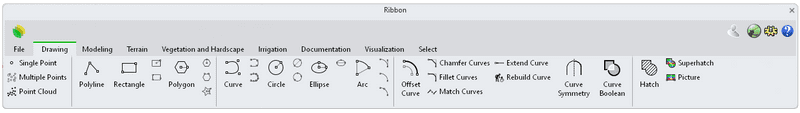
Drawing commands:
Draw points
 Point: Draws a single point object at a specified location.
 Points: Draws multiple point objects.
 Point Cloud: Creates a set of vertices from point objects.
Draw Lines and polylines
 Polyline: Draws a series of joined line segments.
 Rectangle: Draws a rectangular closed polyline with options for starting.
 Rectangle, Center: Draws a rectangle from the center point and a corner.
 Rectangle, 3Points: Draws a rectangle through three points.
 Polygon: Draws a closed polyline with a specified number of sides.
 Polygon, Circumscribed: Draws a polygon where the midpoints of the sides touch an imaginary circle of a specified radius.
 Polygon, Edge: Draws a polygon by defining one edge.
 Polygon, Star: Draws a star-shaped polygon.
Draw Curves
 Curve: Draw a curve from control point locations.
 InterpCrv : Fit a curve through picked locations.
 Sketch : Drag the mouse to draw a curve.
 Circle: Draws a circle from a center location and a radius.
- Circle, Diameter: Draws a circle from points on diameter.
- Circle, 3Points: Draws a circle through three points on the circumference.
 Ellipse: Draws a closed elliptical curve.
- Ellipse, Diameter: Draws the ellipse from points on its axes.
 Arc: Draws an arc with options for center, start, angle, and direction.
 Arc: Start, End, Direction: Arc by start, end, direction at start.
  Arc: Start, End, Radius:Arc by start, end, radius.
 Arc: Start, End, Point on arc:Arc by start, end, point on arc.
Curve Tools
 Offset: Copies a curve parallel at a specified distance from the original curve.
 Chamfer: Creates a line segment between two curves and trims or extends the curves to meet it.
 Fillet:Adds an arc between two curves and trims or extends the curves to the arc.
 Match: Changes a curve end to meet another curve or surface edge with a specified continuity.
 Extend: Extends a curve by its natural extension to a boundary or point.
 Rebuild: Reconstructs curves, surfaces, and extrusion objects to a specified degree and control point number.
 Symmetry: Mirrors a copy of a curve.
 Curve boolean: Trims, splits, and joins curves based on their overlapping regions.
 Hatch: Draws a pattern of lines to fill bounding curves.
 Superhatch: Draws a textured surface to fill bounding curves based on a bitmap repetition.
 Picture: Draws a rectangular planar surface with a bitmap texture.
Modeling Toolbar
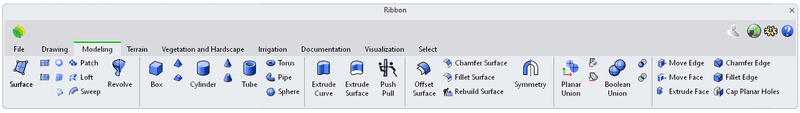
Modeling commands:
Surface Creation
 Surface: Draws a surface from specified corner points.
 Plane: Draws a rectangular planar surface.
 Plane, 3 points: Draws a rectangular planar surface from three points.
 PlanarSrf: Creates a planar surface from planar curves.
 EdgeSrf: Creates a surface from two, three, or four curves.
 NetworkSrf: Fits a surface through a network of crossing curves.
 Patch: Fits a surface through curves and point objects.
 Loft: Fits a surface through profile curves that define the surface shape.
 Sweep: Fits a surface through a series of profile curves that define the surface cross-sections and one curve that defines a surface edge.
 Revolve: Create a surface by revolving a profile curve around an axis.
Solid Creation
 Box: Draws a solid box.
 Pyramid: Draws a pyramid.
 TruncatedPyramid: Draws a pyramid whose apex is truncated by a plane.
 Cylinder: Draws a polysurface cylinder.
 Cone: Creates a surface cone.
 Truncated Cone: Draws a cone whose apex is truncated by a plane.
 Tube: Draws a closed cylinder with a concentric cylindrical hole.
 Torus: Draws a torus (doughnut shape).
 Pipe: Creates a surface, polysurface, or extrusion object with a circular profile around a curve.
 Sphere: Draws a solid sphere.
 Extrude Curve: Creates a surface by tracing the path of a curve in a straight line.
 Extrude Surface: Creates a solid by tracing the path of the surface edges in a straight line.
 PushPull: Extrudes a polysurface face to interactively add or remove volumes on the polysurface.
Surface Tools
 Offset Srf: Copies a surface or polysurface so that locations on the copied surface are the same specified distance from the original surface.
 Chamfer Srf: Creates a ruled surface as a bevel between two input surface edges.
 Fillet Srf: Creates a constant-radius round surface between two surfaces.
 Rebuild Srf: Reconstructs selected curves or surfaces to a specified degree and control point number.
 Symmetry Srf: Mirrors a copy of a surface.
 Planar Union: Merges overlapped planar surfaces into a single surface.
 Planar Difference: Selects two overlapped planar surfaces and creates a surface from the first surface with the overlapped area trimmed off.
 Planar Intersection: Creates a surface from the overlapped area of two planar surfaces.
Solid Tools
 Boolean Union: Combine the volumes of one or more objects.
 Boolean Difference: Subtracts the volume of one set of objects from another.
- Boolean Intersection: Create a new solid from solids' intersected volumes.
 Move Edge: Moves a polysurface edge.
 Move face: Moves a polysurface face.
 Chamfer Edge: Drives a surface face in a straight line to create a solid.
 Fillet Edge: Drives a surface face in a straight line to create a solid.
 Cap: Fills planar holes in objects with planar faces.
Curves from objects
 Project: Project curves/points toward a construction plane to intersect a surface, polysurface or mesh.
 Pull: Moves curves and points toward the normal direction of a surface, mesh or polysurface to find intersections.
 DupEdge: Create a curve that copies a surface edge.
 DupBorder: Create a curve or polyline that copies a surface, polysurface, or mesh border.
 DupFaceBorder: Creates a curve that copies a polysurface face border.
 Intersect: Create point objects or curves at the intersections of curves and surfaces.
Terrain Toolbar
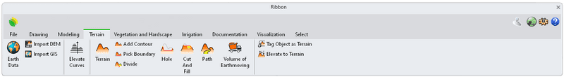
Terrain commands:
 Earth Data: Scans a terrain from the cloud and imports it as a textured mesh or a terrain object.
 Import DEM: Uses the data from a DEM file to import it as a terrain object.
 Import GIS: Uses the data from a .shp file to import it as a terrain object.
 Elevate Curves: Elevates curves every certain distance in order to be used to build a terrain.
 Terrain: Creates a mesh by lifting a surface from 3D curves, contour lines or point clouds.
 Add Contour: Adds a new input data to an existing terrain.
 Pick boundary: Specifies a closed curve to define a terrain boundary.
 Inner Boundary: Specifies a closed curve contained within the terrain area to generate an inner terrain boundary.
 Divide: Divides the terrain into two parts using a closed curve.
 Add Hole: Adds a hole to an existing terrain from a closed curve.
 Add Cut and Fill: Generates cuts and fills in the terrain from a closed curve.
 Add Path: Modifies the terrain geometry in order to place a path in it.
 Volume of Earthmoving: Informs about the total amount of volume from cuts and fills applied on a terrain.
 Tag Object as Terrain: Tag a selected object as a terrain.
 Elevate to Terrain: Moves the selected objects vertically until it lies onto a terrain surface, or onto an object that has been tagged as a terrain.
Vegetation and Hardscape Toolbar
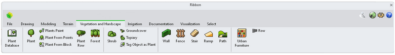
Vegetation and hardscape commands:
Vegetation Tools
 PlantDatabase: Opens the plant species Database.
 Plant: Inserts a specimen of the selected species from the Database.
 Plants Paint: Inserts an array of multiple plants along the path where you hover the mouse pointer.
  Plant from Points: Inserts a plant in the location of the selected points.
 Plant from Blocks: Replace a block instance with the selected plant from the Database.
 Plant Row: Inserts the selected plant species along a path curve.
- Plant Row: Inserts the selected plant species along a path curve.
 Forest: Inserts the selected plant species inside a boundary curve.
 Shrub: Inserts a specimen of the selected shrub species from the Database.
 Groundcover: Fills an area with the selected plant species.
 Topiary: Wraps any geometry with the selected plant species.
 Tag Object as Plant: Tag a selected object as a plant.
Civil Work Tools
 Wall: Inserts a wall by defining its thickness, height and path curve.
 Fence: Inserts a customized fence along a path curve.
 Stair: Inserts a customized stair along a path curve.
 Ramp: Inserts a ramp by defining its slope and path curve.
 Path: Inserts a path by defining its section profile and path curve.
 Urban Furniture: Inserts the selected furniture from the block library.
 Row: Inserts a row of the selected element along a path curve.
Irrigation Toolbar
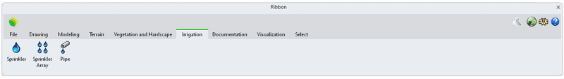
Irrigation commands:
 Sprinkler: Inserts a sprinkler.
 Sprinkler Array: Inserts an array of sprinklers that covers a specific area.
 Pipe: Draws a pipe by connecting sprinklers or using a selected polyline.
Documentation Toolbar
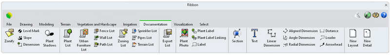
 Zonify: Creates a surface entity that displays the information (name and square meter) of an area in the model.
 Level Mark: Draws an elevation mark as a reference point to determine height or elevation on the plan.
 Slope: Draws an annotation leader with arrowhead displaying the slope of a selected path.
 Dimension: Allows the dimensioning of plants, civil work elements and other entities from a specific coordinate origin point on the plan.
 LaPlantShadows: Creates a shadow effect under the vegetation species in 2D plan views.
Listing Tools
 Plant List: Inserts a table displaying the information of the existing plant species in the model.
 Urban Furniture List: Inserts a table displaying the information of the existing urban furniture blocks in the model.
 Fences List: Inserts a table displaying the information of the existing fences in the model.
 Wall List: Inserts a table displaying the information of the existing walls in the model.
 Path List: Inserts a table displaying the information of the existing paths in the model.
 Zoning List: Inserts a table displaying the information of the existing zonified areas in the model.
 Sprinkler List: Inserts a table displaying the information of the existing sprinklers in the model.
 Pipe List: Inserts a table displaying the information of the existing pipes in the model.
 Terrain List: Inserts a table displaying the information of the existing terrains in the model.
 Export List: Exports the selected list to .xls (Excel) and .html format.
Labeling plants Tools
 Plant Photo: Creates a label with an image loaded from the cloud, and draws a leader pointing to the referenced plant.
 Plant Label: Inserts a customized label displaying the information of the selected plant in the model.
 Plant label Linking: Inserts a customized label displaying the information of a group of plants selected in the model.
 Label: Opens RhinoLands Database.
 Section: Create a plane that hides objects.
Annotation tools
 Text: Creates annotation text.
 Linear Dimension: Draws horizontal or vertical linear dimensions.
 DimAligned: Draw a linear dimension lined up with two points.
 DimAngle: Dimension the angle between two lines.
 DimRadius: Dimension the radius of an arc or circle.
 Distance: Report the distance between two picked locations.
 Leader: Draw an annotation leader with attached text.
 Arrowhead: Create or remove an arrowhead on a curve.
Create Layouts
 New Layout, 1 Detail: Create a print layout viewport.
 Detail, Add:: Add a detail viewport.
Visualization Toolbar
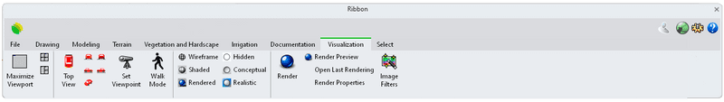
Viewport windows
 Maximize Viewport: Maximizes the active viewport inside the RhinoLands application window.
 4Viewports: Sets up a four-viewport workspace.
 3Viewports: Sets up a three-viewport workspace.
Set view
 Top View: Sets the active view to look at the Top.
 Front View: Sets the active view to look at the Front.
 Back View: Sets the active view to look at the Back.
 Left view: Sets the active view to look at the Left.
 Right view: Sets the active view to look at the Right.
 Perspective view: Sets the active view to look at in Perspective.
 Set Viewpoint: Sets the camera viewpoint from the viewer and target position.
 Walk Mode: Lets you walk through the project using the keyboard and mouse buttons.
Display Modes
 Wireframe: Sets the active viewport to display wireframe mode.
 Shaded: Sets the active viewport to display shade mode.
 Rendered: Sets the active viewport to display rendered mode.
 Hidden: Sets the active viewport to display hidden mode.
 Conceptual: Sets the active viewport to display conceptual mode.
 Realistic: Sets the active viewport to display realistic mode.
Rendering Tools
 Render: Renders the objects using the current renderer.
 Render Preview: Renders the current viewport in the Render window with a rough quality for a fast preview.
 Open Last Rendering: Opens the last rendering image file.
 Image Filters: Applies multiple filters to the rendered images.
Select Toolbar
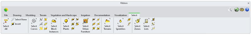
 Select All: Selects all objects.
 Select None: Deselects all objects.
 Select Invert: Deselects all selected objects and selects all visible objects that were not previously selected.
Select drawing and modeling objects
 Select Curves: Selects all curves.
 Select Points: Selects all point objects.
 Select Point clouds: Selects all point cloud objects.
 Select Hatches: Selects hatch objects.
 Select Meshes: Selects all meshes.
 Select Surfaces: Selects all surfaces.
 Select Polysurfaces: Select all polysurfaces.
 Select Block Instances: Select all block instances.
Select vegetation and hardscape objects
 Select Plants: Select all plant objects.
 Select Plant Rows:Select all plant row objects.
 Select Forests: Select all forest objects.
 Select Shrubs: Select all shrub objects.
 Select Groundcovers: Select all Groundcover objects.
 Select Topiaries: Select all topiary objects.
 Select Urban Furniture: Select all Urban Furniture blocks.
 Select Rows: Select all row objects.
 Select Walls: Select all wall objects.
 Select Fences: Select all fence objects.
 Select Stairs: Select all stair objects.
 Select Ramps: Select all ramp objects.
 Select Path: Select path objects.
 Select Terrains: Select all terrain objects.
 Select Sprinklers: Select all sprinkler objects.
 Select Sprinkler Arrays: Select all Sprinkler array objects.
 Select Pipes: Select all pipes objects.
 Select Zones: Select all zone objects.
 Select Lists: Select all list objects.
 Select Plant Photos: Select all plant photo objects.
 Plant Labels: Select all plant lebels.
 Select Labels: Select all label objects.