Terrain Add Hole
 left click
This command generates perforations or gaps in the terrain, commonly used for inserting structures like swimming pools, ponds, or lakes. The hole is created based on a closed curve, which defines the area to be removed. The elevation of the curve will determine the depth of the hole.
This operation also adds a division to the terrain from the same closed curve, as if you were using the laTerrainDivide command.
Add Hole
Steps:
- Pick a terrain. Press Enter or right-click when done.
- Select a closed curve to define the hole area.
- The hole will be created in the terrain.

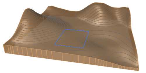
Terrain and the curve selected to create the hole

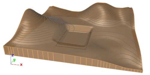
Terrain with the hole created
NoteThe hole won't be appreciated if the curve is situated above the terrain, without intersecting with it.
Control points
The control points of the hole allow you to modify the hole elevation and hole bottom boundary area. They are the same as those of the curve used for this operation. In addition, there is a move control arrow to reposition the entire hole operation.
These control points are integrated with the terrain and are visible when the terrain's control points are enabled.
Control points can be disabled in the Earthmoving tab, in the Properties area of the Edit panel, after selecting the hole operation from the selection list.
NoteThe control points of the subdivision created by a hole depend on the hole control points, regardless whether they are enabled or not in the subdivision settings.
Options and Parameters
The Hole parameters are the same as those for the Cut and Fill operation. They can be edited from the Earthmoving tab in the Properties area of the Edit panel, once selected under the Earthmoving operations list.
For the Earthmoving operations to appear in the selection list, the terrain must first be selected from the viewport.
NoteThe Hole operation only activates the cut option by default. If the fill option is enabled, the operation will change its name from Hole to Cut and Fill in the Earthmoving operations list.
The edit options and parameters of the terrain subdivision generated by this command are the same as those generated with the laTerrainDivide command.
Edit options
These are the edit options for the Hole operation, available in the Edit area of the Edit panel:
