Elevate Curves
This command elevates curves every certain distance in order to be used to build a terrain.
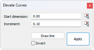
After running the laElevateCurves command, the Elevate Curves dialog will appear.
Steps:
- Define the Elevate Curves parameters in the dialog:
- Start dimension: Elevation of the first curve to elevate.
- Increment. Incremental distance among the contour curves to elevate.
- Click on the Draw line button and draw a line in the model that intersects with the contour curves to elevate.
- Click on the Invert checkbox to invert the order in which the curves are elevated.
- Click on the Apply button and close the dialog.

Elevate Curves dialog
 left click